SOG 3Chailey Common South + CoachingSat 24 February, 2018
Near: Chailey
Level of event: Local
Type of event:
Race
Results
Report
What a gloriously crisp winter's morning for orienteering, and well over 120 of you seem to have agreed! Thank you all for coming to this event on an area that hasn't been used for about 20 years. Thank you also to all the helpers; Einar, Lynda, Di, Mike, Andy, Steve, Jill, Neil, Ralph, Joe, Les, Judith, Bridget, Mike R and Mike for printing and to everyone else working in the background that enables us to hold these events. Also to ESCC for giving us permission to use the area and Chailey Heritage for parking (the parking money will be donated to them and topped up to around £100 I believe).
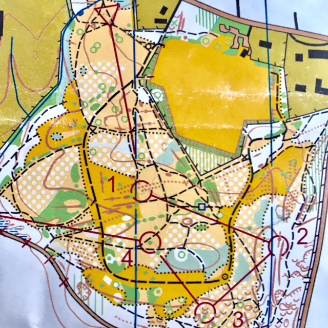
Today's race was the culmination of about 8 months of work as I started the map of the area from scratch back in the summer. Then the bracken was head high and many parts of the area were impenetrable. Over the subsequent months this started to die back, a volunteer team started to do a lot of clearance work (the aim is to restore the heath) and the true majesty of the area started to reveal itself! The map was eventually completed around Christmas time (although every time I visit something has either appeared or changed!) and I was then able to start the planning process. It quickly became apparent that finding good long legs would be difficult so I settled for courses that were more middle distance in nature with shorter legs and lots of direction changes. With the Green and Blue courses I tried to give you direct options whilst the nature of the area allowed me to set more challenging Orange and Yellow courses than might be usual, throwing in alternative line features to follow such as veg boundaries and gullies. I hope that you all found the area and the courses both enjoyable and challenging; if so, then I have succeeded with my aim!
RouteGadget
Is a web app for sharing and comparing orienteering routes. You can draw your own route or upload a GPS track from your watch. It also allows you to watch an animated replay with a simulated mass start.
Pre event info
This event will use a new map of an area that has not been used for orienteering 20 years.
Coaching at 9.15 for newcomers, juniors and those wanting to brush up on their skills. Read more....
SOG Series Info
SOGs are friendly club events where children and newcomers are very welcome. Yellow and Orange courses are suitable for children to run on their own with a bit of practice. Adults are welcome to shadow children until they are confident to go on their own. Green and Blue courses are run or walked by any age group - you can race competitively or just enjoy the woodland.
There are two series of events - autumn and spring of approximately 8 events each. Electronic timing (SI) is used.
Help on the day always appreciated.
Location Info
Nearest town: Chailey
- Postcode: BN8 4EF *
- Lat,Lng:50.97299,-0.03003
- Grid Ref: TQ389210
- Google Map
- Streetmap (OS 50k)
- Bing Map (OS 50k)
- OpenStreetMap
* Postcodes are not very precise in some areas, so don't rely on them for an exact location.
Directions / Parking
Parking at Chailey Heritage (post code BN8 4EF) using the entrance on the A272 to the west of the double roundabout in North Chailey village.
Public Transport
Nearest trains at Haywards Heath
Course Information
Blue 5.6km, Green 3.6km, Orange 2.5km, Yellow 1.5km
Yellow course competitors should note that line features other than paths will be used (i.e. a gully and a veg boundary) and that some controls will be just off the line feature (but visible).
The start is about 300m from the car park and involves a short walk alongside the A272 on a pavement. Parents are requested to accompany their children to and from the start and finish please.
Entry Details
Pre-entry via Racesignup.co.uk Newcomers are welcome and eligible for a free trial session - if you'd like to reserve a map or discuss the event please email our membership secretary.
BOF member fees: Seniors £6.50, Juniors £3.25, SO Juniors free.
Non member fees: Seniors £7.50, Juniors £3.25.
'Dibber' hire:
Electronic punching (SI) chips are available to hire. SIAC (contactless): £2 (juniors £1), non-SIAC (not contactless) £1 (juniors £0.5)
Registration open
9:45 to 10:45
Start Times
10:00 to 11:00. Courses close at 12:30.
Map Details
1:7500 newly mapped by Chris Hooker in the summer and autumn of 2017 to ISOM 2017. Note that many small seasonal paths are not on the map and that some veg boundaries indicate areas of dead bracken.
Terrain Description
Mixture of open managed heathland and small pockets of woodland. There is an abundance of depressions and gullies as well as a good path network. This area was last used in 1997 and has changed considerably since then.
Dog restrictions
Dogs allowed
Facilities
None
Miscellaneous
If lost then head north. This will bring you close to the playing field which is near to the start. If you come to the northern boundary then follow it east to the crossing point and then head north.
This is an exposed site so warm clothing and appropriate footware are recommended as is the carrying of a whistle. In very poor weather the wearing of cagoules may be compulsory.
The area is popular with the public (including dog walkers and horse riders), please be courteous to them.
Contacts / Officials
Planner: Chris Hooker
Organiser: Steve Blount
Controller: